Ecuador
South AmericaLevel of surfing
Evolved
Quality of surf
Good
Call code
593
Net code
ec
Area
256370
Coastline
2,237 km
Climate
Tropical along coast, becoming cooler inland at higher elevations
Hazards
Extreme Heat, Difficult Access, Coup / Civil Unrest
Best Months
June - August
Population
13810000
Currency
US Dollar (USD)
Time Zone
ROMEO (UTC-5)
Special Requirements
Lengthy VISA Process
introduction
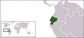
Wrh2: Location map for Ecuador, 21 July 2006
Ecuador is located in north western part of South America, along the Pacific Ocean coastline, lying on the Equator between Colombia.
Its capital city is one of the first UNESCO World Heritage cities, Quito and many other cities and sites are integrated in the prestige Unesco World Heritage Sites. Such cities and best known places to visit are the Galapagos Islands and the city of Cuenca.
history
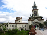
The lifted lorax: Loga city gates, 4 May 2007
Many civilisations existed throughout Ecuador, such as the Valdivia Culture and Machalilla Culture on the coast, the Quitus (short distance from Quito) and the Cañari (short distance from Cuenca).
Each civilsation developed their own unqiue architecture, pottery, and religious interests and after years of fiery resistance by the Cayambes and other tribes, what is now Ecuador fell to the Incan expansion and was assimilated loosely into the Incan empire.
surfing
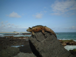
Datune: Galapagos Iguana; 2007
The leading edge of the Ecuadorian coast is constantly being reformed due to the vast alluvial dumpings of several great south american rivers. This coast has excellent exposure to the south west and north west pacific swells from both the north and south hemisphere. Right on the ecuator the prevailing winds are very light and typically produce superior surface conditions.
Light winds bring a reliance on good groundswell to produce wave action. Nothing wrong with that of course but swell has a long way to go before it reaches the coast and the nearby Galapagos Islands, take heart however in that whatever does reach the coast will have travelled about as far as swell is capable of travelling and will be as clean as it gets. The Galapagos Islands are a virtually uncharted surfing masterpiece. The untamed beauty of these islands inspired Charles Darwin to boldly suggest that maybe there was more to the mystery of how the natural world all fits together that the Old Testament suggested.
The islands are effectively a minature map of a global continental system, each with their own specifically adapted wildlife. Darwin discovered several of these species, many found no where else on the planet, is there any greater reward than making your own unique discovery amongst this most primordial and significant of all island chains.
travel
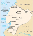
CIA World Factbook 2002: Map of Ecuador, 8 August 2003
Getting around Ecuador is simple. Intercity buses travel to almost everywhere in Ecuador and most cities have a central bus terminal where you purchase tickets. Buses are cheap; long-distance buses typically cost from $1 to $2 per hour, depending on the distance. There are a few first class buses called "Ejecutivo", these buses will cost a little more than the regular busses but are generally more comfortable and safer.
Another way, yet more expensive way of getting around Ecuador is by getting a taxi. Taxi's are widely available all throughout the country and generally would not cost more than $10 per hour. Evening rates are often double though, so be careful!
weather
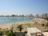
Engel16: Salinas beach in Ecuador, 2007
Because Ecuador is situated at the equator, it experiences little variation in daylight hours during the course of a year.
However, the climate in the country varies greatly within the different divisions. The Pacific coastal area has a tropical climate, with a severe rainy season. The climate in the Andean highlands is temperate and relatively dry, and the Amazon basin on the eastern side of the mountains shares the climate of other rain forest zones.
what to pack

Stijn: Nike Air Zoom track shoes, with carbon 6mm spikes attached; 1 July 2006
Same as in the Rest of South America...Pack light when travelling to Ecuador, as it is very hot there (lightweight clothing in general), and drink a lot of water (bottled water is recommended). You may need a bagback to travel in Ecuador, as this is the best way to deal with transportation...There's no need to bring your expensive belongings, but you need warm clothes (for the Andes) and light clothes (for the coast). Think about something to protect you from the rain as it may be rainy. Make sure you take a good sunscreen (SPF 30+); a good insect repellent wouldn't hurt much either. Comfortable walking shoes, as there are many places to see.
Bring on the medicines you are used to take. Internet cafes are pretty much everywhere.
top rated spots
surfing divisions
Partners